Peralta Stones
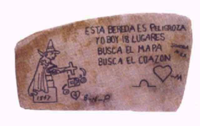
The Peralta Stones were discovered sometime between 1949 and 1956 by a man who stopped by the side of the road at Apache Junction in the Arizona desert.
What most people do not realize is that carving maps on stone was the preferred method by the Spanish to hide their many mines and treasures utilizing a system of coded symbols.
The Peralta Stones represent the area of land granted to the Peralta Family by the Spanish Crown for mining purposes and a series of coded symbols which can be used to decipher the stone maps to find the location of the Peralta mines when placed in the proper order and format. They point the way to numerous mines and smelters in the four corners area of the western United states which was all Spanish owned territory at the time of the grants.
Peralta Stones
After reviewing the Peralta Stones go to the Peralta Canyon
The staff at HSS took a shot at deciphering the Peralta stones ten to twelve years ago, using the mathematical formula and symbolism they had learned while deciphering a site in the State of Florida. The coded instructions directed them to a certain compass bearing, and a distance measurement. At this time an HSS staff member was instructed to go to a certain area in Arizona and photograph a small area. The results of this photography proved to the HSS staff they were interpreting the coded system properly and can be be seen on this website by going to Signs and Symbols and click on Arizona.
An animated sequence of the symbols within this stone map is also available on the site to make for easier viewing for the uninitiated treasure hunter who has not had the experience of locating this particular type of symbolism used by the Spanish to hide their many mines and smelters.
* These symbols were found in Arizona and if viewed properly superimposed over a present day topographical map will show this symbolic mapping system works and it will lead you to this one area which has three mines and a cavern of Gold with a waterfall over the cavern.
There are 3 campsites and the main camp which makes 4 campsites, two caves and a large crater with a gorge and a stream running through the gorge and a smelter just to the West of the Church patio area. There are 3 mines. There is a cavern of Gold with water falling over the Gold. There is another cavern of Gold at an opposite compass bearing. The compass bearings and distances to these areas can be found in the Wizard Workshop.

